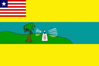
Overview of Maryland County

Flag of Maryland County
Photo Credit: MIA Related Documents
|
Maryland County is a county in the southeastern portion of the West African nation of Liberia. One of 15 counties that comprise the first-level of administrative division in the nation, it has two districts. Harper serves as the capital with the area of the county measuring 2,297 square kilometres (887 sq mi). As of the 2008 Census, it had a population of 136,404, making it the seventh most populous county in Liberia.
Named after the State of Maryland in the United States, it joined Liberia in 1857. The most populous city in the county is Pleebo with 22,963 residents, while Maryland's County Superintendent is Nazarene B. Tubman. The county is bordered by Grand Kru County to the west and River Gee County to the north. The eastern part of Maryland borders the nation of Côte d'Ivoire, separated by the Cavalla River.
Maryland was first established as a colony of the Maryland State Colonization Society 1834[3] but was not granted independence until 1854. The Maryland colony declared its independence from the Colonization Society but did not become part of the Republic of Liberia. It held the land along the coast between the Grand Cess and San Pedro Rivers. In 1856, the independent state of Maryland (Africa) requested military aid from Liberia in a war with the Grebo and Kru peoples who were resisting the Maryland settlers' efforts to control their trade in slaves. President Roberts assisted the Marylanders, and a joint military campaign by both groups of Americo-Liberian colonists resulted in victory. On February 28, 1857, the Republic of Maryland joined Liberia as Maryland County.
Districts of Maryland County include (2008 population):
- Gwelekpoken
- Harper
- Karluway #1
- Karluway #2
- Nyonken
- Pleebo/Sodoken
- Whojah